
The excavator shows up Monday morning. The crew gets to work. You don’t have a documented record of what the site looked like. The client doesn’t. The property manager doesn’t. Nobody does.
Three months later, there’s a drainage issue in the yard. Or a retaining wall that the client says wasn’t cracked before. Or a question about where the property line actually sits.
And you have nothing to point to.
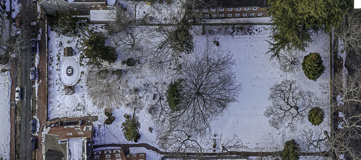
What a Baseline Aerial Actually Captures
A pre-construction aerial isn’t a pretty picture. It’s a legal and operational record.
Shot before work begins, it documents site conditions in full: existing drainage patterns, grade changes, access points, structures on the property, adjacent property conditions, and the general state of the landscape before your crew touches it.
From 100 to 150 feet, you can see the full site in a single frame. Property boundaries in context. How water moves across the grade. What was already there and what wasn’t.
That record protects you. It protects your client. And it removes ambiguity from conversations that would otherwise come down to competing memories.
The Operational Value Beyond Protection
Baseline documentation isn’t only defensive.
A detailed pre-construction aerial gives you a reference frame that informs how the project develops. You can see site conditions that aren’t always obvious at ground level: subtle grade changes, drainage paths, areas where water pools. Contractors who review their baseline aerials before work starts catch details that save time and prevent surprises mid-project.
It’s the difference between starting a project and starting a project prepared.

It’s Also the Foundation for Progress Documentation
If you’re tracking a project through multiple phases: demo, rough grade, install, finish. The baseline is phase zero. Every subsequent aerial gets measured against it.
That progression tells a story. Before the season started, the site looked like this. At the midpoint, it looked like this. At completion, it looked like this.
That story is your portfolio. It’s what you show the next client who asks what you can do with their kind of property.
How to Use This
Controlled Creations offers baseline aerials as a standalone capture or as the first shoot in a construction progress package. Turnaround is 48 to 72 hours. Files are delivered edited and formatted. Not raw.
If you have a project breaking ground this spring, the time to schedule the baseline is before the crew arrives — not after.
No responses yet